Sensor locations
| Location Code | HD |
|---|---|
| Opening Date | 13-02-2020 |
| End Date | - |
| Housing Class | - |
| Housing Description | - |
| sensor depth below station | 0.3 m |
| Distance to Building (m) | - |
| Location Code | (none) |
|---|---|
| Opening Date | 13-02-2020 |
| End Date | - |
| Housing Class | - |
| Housing Description | - |
| sensor depth below station | 0.4 m |
| Distance to Building (m) | - |
Current Instrumentation
| Location code | HD |
|---|---|
| On date | 21-02-2023 13:00:00 |
| Off date | - |
| Sensor model | PRS |
| Sensor manufacturer | iTem |
| Digitizer model | Centaur |
| Digitizer manufacturer | Nanometrics |
| Channels | HDF |
| Stream Noise (last week) | HDF |
| Location code | (none) |
|---|---|
| On date | 21-02-2023 13:00:00 |
| Off date | - |
| Sensor model | LE-3DliteMkII |
| Sensor manufacturer | Lennartz |
| Digitizer model | Centaur |
| Digitizer manufacturer | Nanometrics |
| Channels | EHE , EHN , EHZ |
| Stream Noise (last week) | EHE , EHN , EHZ |
| Location code | HD |
|---|---|
| On date | 13-02-2020 10:00:00 |
| Off date | 2023-02-21 13:00:00 |
| Waveform Access | restricted |
| Sensor model | PRS |
| Sensor manufacturer | iTem |
| Digitizer model | Taurus |
| Digitizer manufacturer | Nanometrics |
| Channels | HDF |
| Location code | (none) |
|---|---|
| On date | 13-02-2020 10:00:00 |
| Off date | 2023-02-21 13:00:00 |
| Waveform Access | restricted |
| Sensor model | LE-3DliteMkII |
| Sensor manufacturer | Lennartz |
| Digitizer model | Taurus |
| Digitizer manufacturer | Nanometrics |
| Channels | EHE , EHN , EHZ |
Site Characterization
|
channel group |
Empirical Amplification |
|---|---|
| 9S.MONT1..EH | 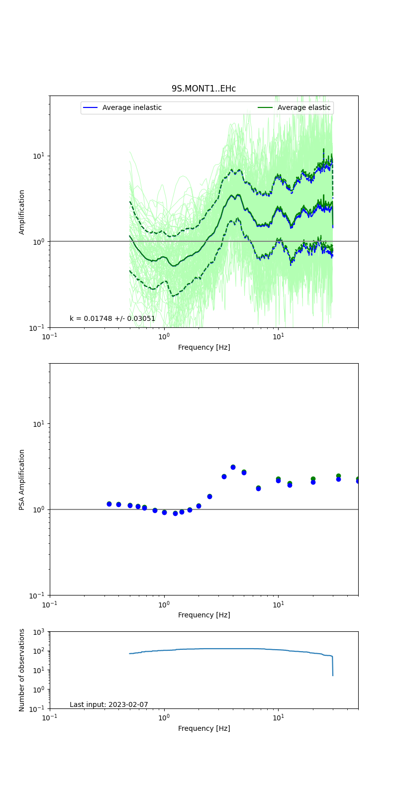 |
Obtained from spectral modeling of small earthquakes with constant update.
- Top: Fourier amplification with elastic (dashed line) and anelastic (solid line) amplification functions;
- Centre: 5% damped response spectra amplification (anelastic);
- Bottom: Number of recordings used.
See Edwards et al. (2013), Determination of Site Amplification from Regional Seismicity: Application to the Swiss National Seismic Networks. Seismological Research Letters, 84(4), 611–621.
| measurements nearby | list... |
|---|