Station Overview

Overview Location not available
Picture Gallery details...
Network 2A
Station Code GRAE2
Station Description Graechen, GRAE2, VS
Latitude (WGS84) 46.17672
Longitude (WGS84) 7.859407
Station altitude (CH1903) 2865.0
running from 2008-12-09
...until 2009-04-15
Waveform Access open
Sensor Types Velocimeter
Geological Unit Rock slide deposits
Site Morphology Class
Site Morphology Description Rock slope
Ground type EC8
Ground type SIA
Basin Information not in a sedimentary basin with possible 2D/3D effects
Reference
Resonance Frequency (Hz) -
Uncertainty Factor -
Vs 30 (m/s) -
Location Map


Federal Office of Topograpy: National Map 1:25‘000
Topography Map


Federal Office of Topograpy: DHM25: Digital Height Model 1:25000
Geology Map

Federal Office of Topograpy: Geological map of Switzerland 1:500‘000

Sensor locations

Location Code (none)
Opening Date 09-12-2008
End Date 2009-04-15
Housing Class Urban free field
Housing Description Ground floor of a wooden hut (sensor on a metallic tripod hammered in the ground)
sensor depth below station 0.0 m
Distance to Building (m) 5

Current Instrumentation

No open epochs

Location code (none)
On date 09-12-2008 00:00:00
Off date 2009-04-15 00:00:00
Waveform Access open
Sensor model LE-3D-5s
Sensor manufacturer Lennartz
Digitizer model
Digitizer manufacturer
Channels EHE , EHN , EHZ

Site Characterization

channel group
Empirical Amplification
2A.GRAE2..EH not available

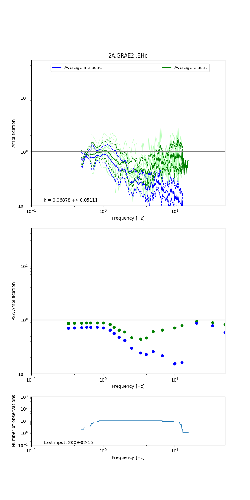
Obtained from spectral modeling of small earthquakes with constant update.

  • Top: Fourier amplification with elastic (dashed line) and anelastic (solid line) amplification functions;
  • Centre: 5% damped response spectra amplification (anelastic);
  • Bottom: Number of recordings used.

See Edwards et al. (2013), Determination of Site Amplification from Regional Seismicity: Application to the Swiss National Seismic Networks. Seismological Research Letters, 84(4), 611–621.

H/V pick image:
Authoritative Site Characterization Analysis -
measurements nearby list...