Sensor locations
| Location Code | (none) |
|---|---|
| Opening Date | 20-06-2019 |
| End Date | - |
| Housing Class | Tunnel |
| Housing Description | Sensor in 91m long tunnel, 27.8m directly below free surface, 90m from the only entrance. Both Sensors placed on 30cm high concrete pedestal on rock, insulated with a sheet metal cover. Tunnel is manmade, used once a year by power plant operators to measure the slope slide. Rarely used roads and a few buildings in about 100m distance. |
| sensor depth below station | -0.3 m |
| Distance to Building (m) | - |
Current Instrumentation
| Location code | (none) |
|---|---|
| On date | 20-06-2019 06:00:00 |
| Off date | - |
| Sensor model | EpiSensor ES-T |
| Sensor manufacturer | Kinemetrics |
| Digitizer model | Q330HRS |
| Digitizer manufacturer | Quanterra |
| Channels | HGE , HGN , HGZ |
| Stream Noise (last week) | HGE , HGN , HGZ |
| Location code | (none) |
|---|---|
| On date | 20-06-2019 06:00:00 |
| Off date | - |
| Sensor model | STS2.5 |
| Sensor manufacturer | Streckeisen |
| Digitizer model | Q330HRS |
| Digitizer manufacturer | Quanterra |
| Channels | BHE , BHN , BHZ , HHE , HHN , HHZ |
| Stream Noise (last week) | BHE , BHN , BHZ , HHE , HHN , HHZ |
Site Characterization
|
channel group |
Empirical Amplification |
|---|---|
| CH.WGT..HH |  |
| CH.WGT..HG | 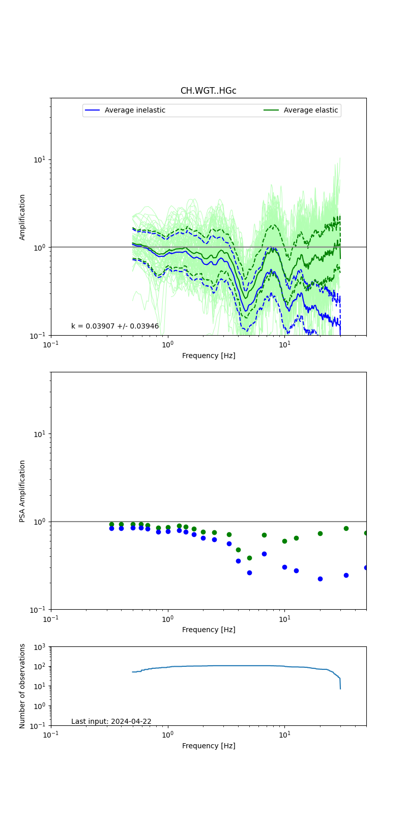 |
Obtained from spectral modeling of small earthquakes with constant update.
- Top: Fourier amplification with elastic (dashed line) and anelastic (solid line) amplification functions;
- Centre: 5% damped response spectra amplification (anelastic);
- Bottom: Number of recordings used.
See Edwards et al. (2013), Determination of Site Amplification from Regional Seismicity: Application to the Swiss National Seismic Networks. Seismological Research Letters, 84(4), 611–621.
| measurements nearby | list... |
|---|