Station Overview
| Overview Location |
 |
|---|---|
| Picture Gallery | details... |
| Geological Unit | Marl (Molasse, Untere Oehninger Schichten, Miocene) |
|---|---|
| Site Morphology Class |
T2 T1: flat; T2: slope; T3: ridge and T4: steep ridge; following Pessina and Fiorini (2014) A GIS procedure for fast topographic characterization of seismic recording stations, Soil Dynamics and Earthquake Engineering, 63, p248-258 |
| Site Morphology Description | Fluvial geomorphology: alluvial slope, plain, cone |
| Ground type EC8 | B |
| Ground type SIA | C |
| Basin Information | not in a sedimentary basin with possible 2D/3D effects |
| Reference | Fäh Donat, Fritsche S., Poggi V. et al., "Determination of Site Information for Seismic Stations in Switzerland. Work Package 4: Pegasos Refinement Project", Swiss Seismological Service, ETH Zürich, 2009 |
Sensor locations
| Location Code | 01 |
|---|---|
| Opening Date | 21-09-2022 |
| End Date | - |
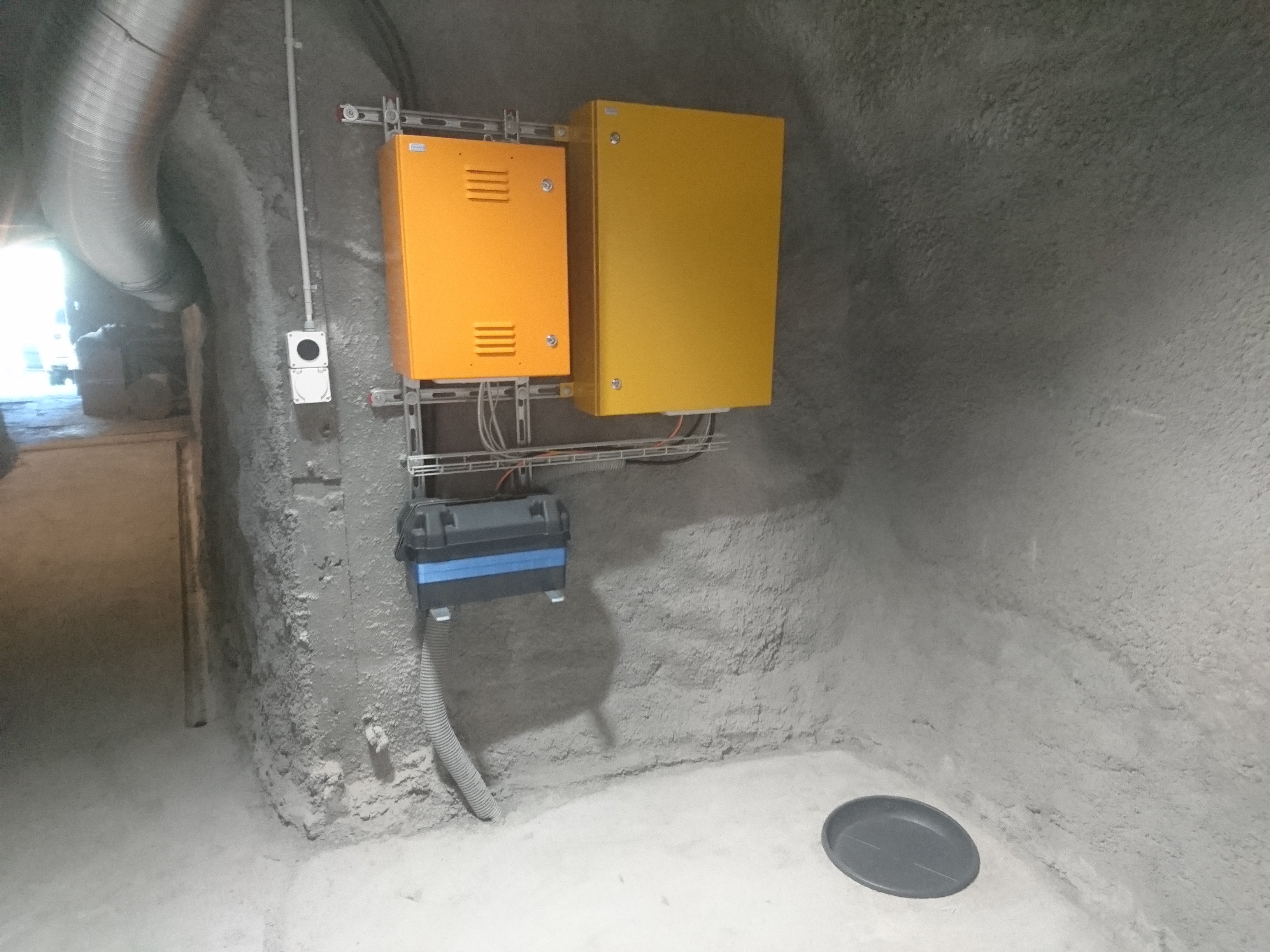
| Housing Class | Free field |
| Housing Description | Sensors installed 5m below free surface in underground shelter. BB sensor and accelerometer placed in a 65cm deep borehole, coupled to the sediment via sand. BB and accelerometer are combined in one casing (Cascadia Posthole sensor.) |
| sensor depth below station | 0.0 m |
| Distance to Building (m) | - |
| Location Code | (none) |
|---|---|
| Opening Date | 29-08-2003 |
| End Date | 2021-12-01 |
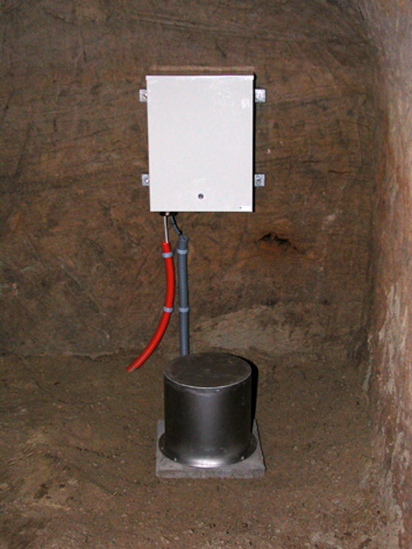
| Housing Class | Tunnel |
| Housing Description | Sensor in tunnel 7m directly below free surface, 15m from nearest entrance. Sensor placed on concrete pedestal on sandstone. |
| sensor depth below station | 0.0 m |
| Distance to Building (m) | - |
Current Instrumentation
| Location code | 01 |
|---|---|
| On date | 21-09-2022 16:05:00 |
| Off date | - |
| Sensor model | Titan 2G |
| Sensor manufacturer | Nanometrics |
| Digitizer model | Centaur |
| Digitizer manufacturer | Nanometrics |
| Channels | HGE , HGN , HGZ |
| Stream Noise (last week) | HGE , HGN , HGZ |
| Location code | 01 |
|---|---|
| On date | 21-09-2022 16:05:00 |
| Off date | - |
| Sensor model | Trillium Compact 120s |
| Sensor manufacturer | Nanometrics |
| Digitizer model | Centaur |
| Digitizer manufacturer | Nanometrics |
| Channels | BHE , BHN , BHZ , HHE , HHN , HHZ |
| Stream Noise (last week) | BHE , BHN , BHZ , HHE , HHN , HHZ |
| Location code | (none) |
|---|---|
| On date | 21-07-2006 00:00:00 |
| Off date | 2021-12-01 10:15:00 |
| Waveform Access | open |
| Sensor model | LE-3D-5s |
| Sensor manufacturer | Lennartz |
| Digitizer model | Trident |
| Digitizer manufacturer | Nanometrics |
| Channels | EHE , EHN , EHZ |
| Location code | (none) |
|---|---|
| On date | 20-02-2004 00:00:00 |
| Off date | 2006-07-21 00:00:00 |
| Waveform Access | open |
| Sensor model | LE-3D-5s |
| Sensor manufacturer | Lennartz |
| Digitizer model | Trident |
| Digitizer manufacturer | Nanometrics |
| Channels | EHE , EHN , EHZ |
| Location code | (none) |
|---|---|
| On date | 08-09-2003 00:00:00 |
| Off date | 2004-02-20 00:00:00 |
| Waveform Access | open |
| Sensor model | LE-3D-5s |
| Sensor manufacturer | Lennartz |
| Digitizer model | Trident |
| Digitizer manufacturer | Nanometrics |
| Channels | EHE , EHN , EHZ |
| Location code | (none) |
|---|---|
| On date | 29-08-2003 12:00:00 |
| Off date | 2003-09-08 00:00:00 |
| Waveform Access | open |
| Sensor model | LE-3D-5s |
| Sensor manufacturer | Lennartz |
| Digitizer model | Trident |
| Digitizer manufacturer | Nanometrics |
| Channels | EHE , EHN , EHZ |
Site Characterization
|
channel group |
Empirical Amplification |
|---|---|
| CH.STEIN.01.HG | 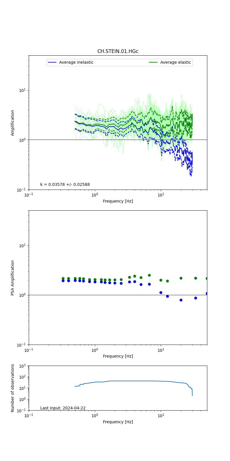 |
| CH.STEIN.01.HH | 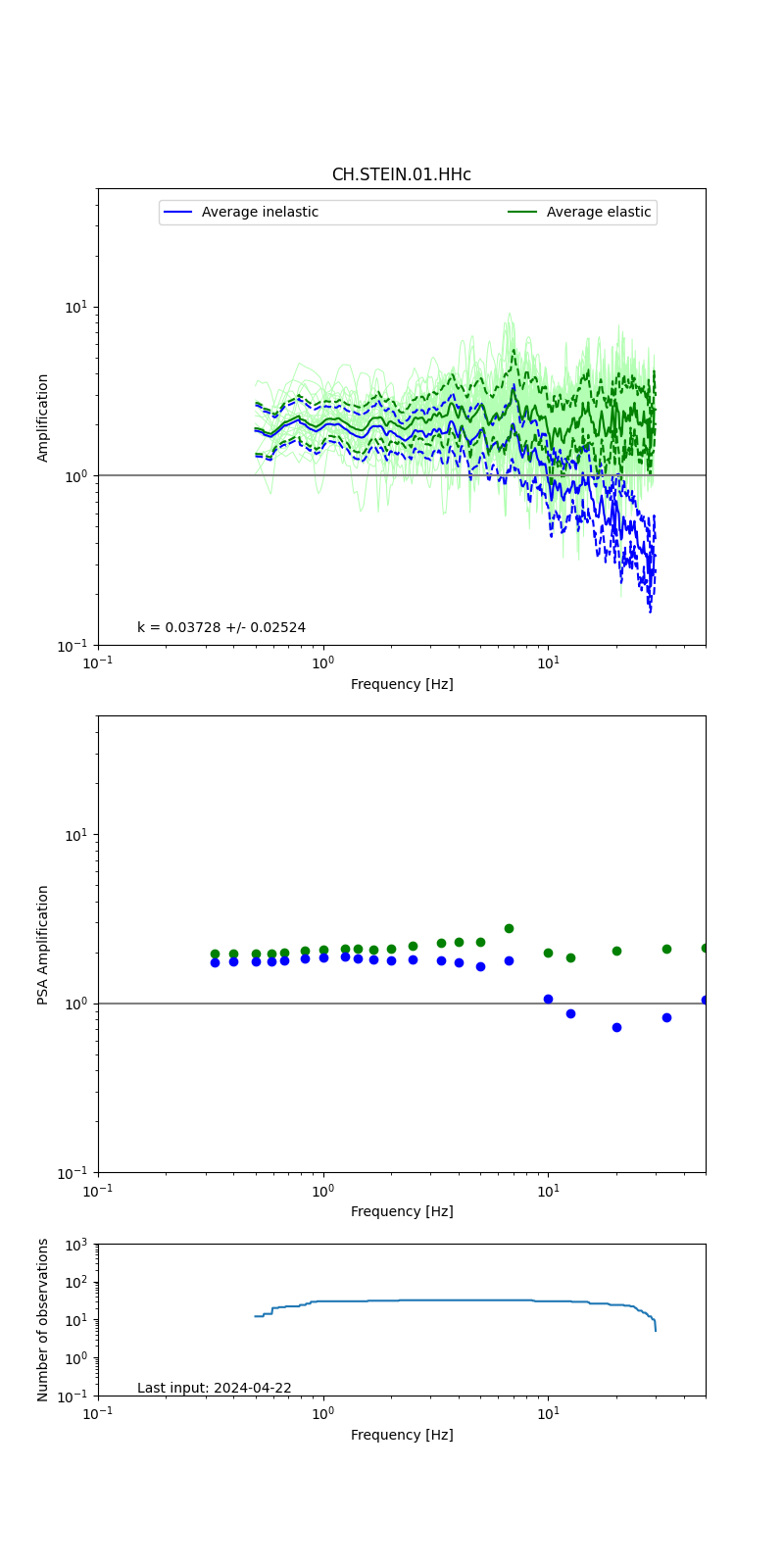 |
| CH.STEIN..EH | 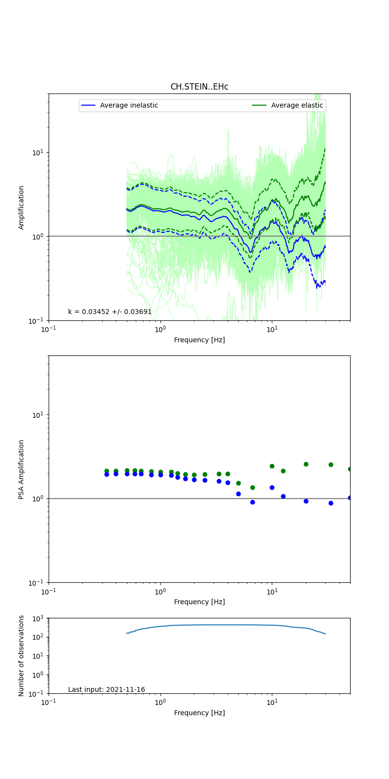 |
Obtained from spectral modeling of small earthquakes with constant update.
- Top: Fourier amplification with elastic (dashed line) and anelastic (solid line) amplification functions;
- Centre: 5% damped response spectra amplification (anelastic);
- Bottom: Number of recordings used.
See Edwards et al. (2013), Determination of Site Amplification from Regional Seismicity: Application to the Swiss National Seismic Networks. Seismological Research Letters, 84(4), 611–621.
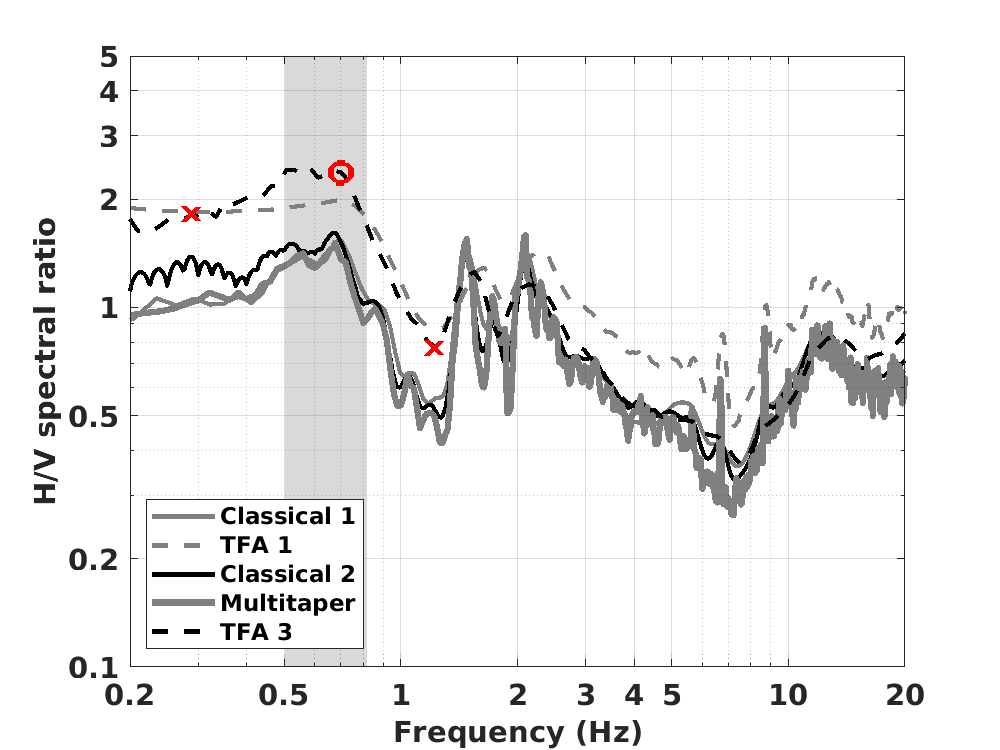
| H/V pick image: |
 |
|---|---|
| Authoritative Site Characterization Analysis | details... |
| measurements nearby | list... |
|---|