Station Overview
| Overview Location | not available |
|---|---|
| Picture Gallery | details... |
| Geological Unit | Limestone (Lower Cretaceous) |
|---|---|
| Site Morphology Class |
T2 T1: flat; T2: slope; T3: ridge and T4: steep ridge; following Pessina and Fiorini (2014) A GIS procedure for fast topographic characterization of seismic recording stations, Soil Dynamics and Earthquake Engineering, 63, p248-258 |
| Site Morphology Description | Rock slope |
| Ground type EC8 | |
| Ground type SIA | |
| Basin Information | not in a sedimentary basin with possible 2D/3D effects |
| Reference |
Sensor locations
| Location Code | (none) |
|---|---|
| Opening Date | 06-02-2002 |
| End Date | - |
| Housing Class | Tunnel |
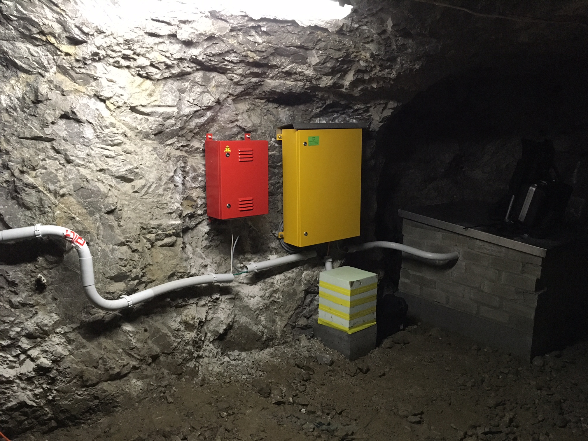
| Housing Description | Sensor in tunnel, 33m directly below free surface, 55m from nearest entrance. Tunnel system is several hundred meters long and is rarely used by power plant operators. The distance from the sensor to the eastern top end of the dam is 345m. BB-Sensor stands on marble plate, placed on ~40cm high concrete pedestal on rock. Epi sensor installed 2m west of the broadband sensor, on ~40cm high concrete pedestal on rock. |
| sensor depth below station | 0.0 m |
| Distance to Building (m) | - |
Current Instrumentation
| Location code | (none) |
|---|---|
| On date | 04-11-2016 19:00:00 |
| Off date | - |
| Sensor model | EpiSensor ES-T |
| Sensor manufacturer | Kinemetrics |
| Digitizer model | Q330HRS |
| Digitizer manufacturer | Quanterra |
| Channels | HGE , HGN , HGZ |
| Stream Noise (last week) | HGE , HGN , HGZ |
| Location code | (none) |
|---|---|
| On date | 04-11-2016 19:00:00 |
| Off date | - |
| Sensor model | STS2.5 |
| Sensor manufacturer | Streckeisen |
| Digitizer model | Q330HRS |
| Digitizer manufacturer | Quanterra |
| Channels | BHE , BHN , BHZ , HHE , HHN , HHZ |
| Stream Noise (last week) | BHE , BHN , BHZ , HHE , HHN , HHZ |
| Location code | (none) |
|---|---|
| On date | 13-02-2002 00:00:00 |
| Off date | 2016-11-04 19:00:00 |
| Waveform Access | open |
| Sensor model | EpiSensor ES-T |
| Sensor manufacturer | Kinemetrics |
| Digitizer model | HRD24 |
| Digitizer manufacturer | Nanometrics |
| Channels | HGE , HGN , HGZ |
| Location code | (none) |
|---|---|
| On date | 13-02-2002 00:00:00 |
| Off date | 2016-11-04 19:00:00 |
| Waveform Access | open |
| Sensor model | STS2_gen3 |
| Sensor manufacturer | Streckeisen |
| Digitizer model | HRD24 |
| Digitizer manufacturer | Nanometrics |
| Channels | BHE , BHN , BHZ , HHE , HHN , HHZ |
| Location code | (none) |
|---|---|
| On date | 06-02-2002 00:00:00 |
| Off date | 2002-02-13 00:00:00 |
| Waveform Access | open |
| Sensor model | STS2_gen3 |
| Sensor manufacturer | Streckeisen |
| Digitizer model | HRD24 |
| Digitizer manufacturer | Nanometrics |
| Channels | BHE , BHN , BHZ , HHE , HHN , HHZ |
Site Characterization
|
channel group |
Empirical Amplification |
|---|---|
| CH.SENIN..HH |  |
| CH.SENIN..HG | 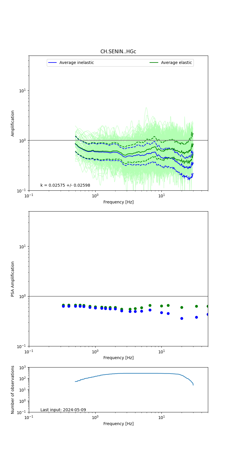 |
Obtained from spectral modeling of small earthquakes with constant update.
- Top: Fourier amplification with elastic (dashed line) and anelastic (solid line) amplification functions;
- Centre: 5% damped response spectra amplification (anelastic);
- Bottom: Number of recordings used.
See Edwards et al. (2013), Determination of Site Amplification from Regional Seismicity: Application to the Swiss National Seismic Networks. Seismological Research Letters, 84(4), 611–621.
| measurements nearby | list... |
|---|