Station Overview
| Overview Location | not available |
|---|---|
| Picture Gallery | details... |
| Geological Unit | Granite |
|---|---|
| Site Morphology Class |
T1 T1: flat; T2: slope; T3: ridge and T4: steep ridge; following Pessina and Fiorini (2014) A GIS procedure for fast topographic characterization of seismic recording stations, Soil Dynamics and Earthquake Engineering, 63, p248-258 |
| Site Morphology Description | Underground below the Rhine alluvial plain |
| Ground type EC8 | |
| Ground type SIA | |
| Basin Information | not in a sedimentary basin with possible 2D/3D effects |
| Reference |
Sensor locations
| Location Code | BT |
|---|---|
| Opening Date | 14-02-2006 |
| End Date | - |
| Housing Class | Borehole |
| Housing Description | Casing: steel; diameter unknown; locking mechanism unknown (Peter Malin sensor); wet. Sensor at 2740m below surface |
| sensor depth below station | 2740.0 m |
| Distance to Building (m) | - |
| Location Code | (none) |
|---|---|
| Opening Date | 31-10-2006 |
| End Date | - |
| Housing Class | Borehole |
| Housing Description | Casing: steel; diameter unknown; locking mechanism unknown (Peter Malin sensor); wet. Sensor at 2740m below surface |
| sensor depth below station | 2740.0 m |
| Distance to Building (m) | - |
| Location code | BT |
|---|---|
| On date | 24-11-2006 00:00:00 |
| Off date | 2012-05-10 23:59:59 |
| Waveform Access | restricted |
| Sensor model | HS-1LT |
| Sensor manufacturer | OYO Geospace |
| Digitizer model | 130 |
| Digitizer manufacturer | Reftek |
| Channels | GH2 , GH3 , GHZ |
| Location code | BT |
|---|---|
| On date | 03-11-2006 00:00:00 |
| Off date | 2006-11-23 23:59:59 |
| Waveform Access | restricted |
| Sensor model | BK8318 |
| Sensor manufacturer | Bruel and Kjaer |
| Digitizer model | 130 |
| Digitizer manufacturer | Reftek |
| Channels | GG2 , GG3 , GGZ |
| Location code | BT |
|---|---|
| On date | 26-07-2006 00:00:00 |
| Off date | 2006-11-03 00:00:00 |
| Waveform Access | restricted |
| Sensor model | BK8318 |
| Sensor manufacturer | Bruel and Kjaer |
| Digitizer model | 130 |
| Digitizer manufacturer | Reftek |
| Channels | GG2 , GG3 , GGZ |
| Location code | BT |
|---|---|
| On date | 14-02-2006 00:00:00 |
| Off date | 2006-06-20 23:59:59 |
| Waveform Access | restricted |
| Sensor model | HS-1LT |
| Sensor manufacturer | OYO Geospace |
| Digitizer model | 130 |
| Digitizer manufacturer | Reftek |
| Channels | GH2 , GH3 , GHZ |
| Location code | (none) |
|---|---|
| On date | 31-10-2006 11:11:00 |
| Off date | 2012-05-10 10:00:00 |
| Waveform Access | restricted |
| Sensor model | HS-1LT |
| Sensor manufacturer | OYO Geospace |
| Digitizer model | |
| Digitizer manufacturer | |
| Channels | EH2 , EH3 , EHZ |
| Location code | (none) |
|---|---|
| On date | 31-10-2006 11:11:00 |
| Off date | 2006-11-24 12:00:00 |
| Waveform Access | restricted |
| Sensor model | BK8318 |
| Sensor manufacturer | Bruel and Kjaer |
| Digitizer model | |
| Digitizer manufacturer | |
| Channels | HG1 , HG2 , HG3 |
Site Characterization
|
channel group |
Empirical Amplification |
|---|---|
| CH.OTER2.BT.GH |  |
| CH.OTER2.BT.GG |  |
| CH.OTER2..HG |  |
| CH.OTER2..EH | 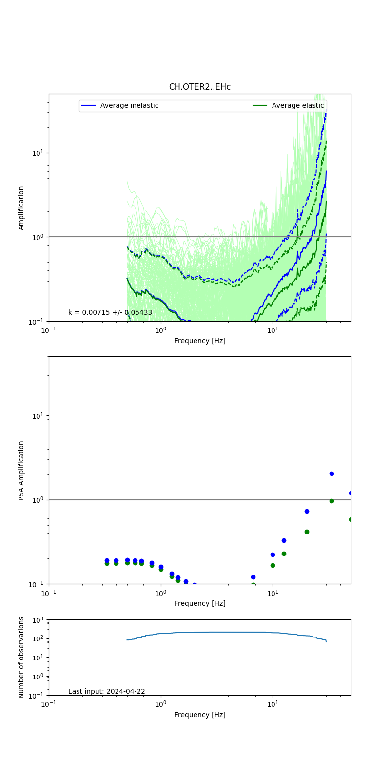 |
Obtained from spectral modeling of small earthquakes with constant update.
- Top: Fourier amplification with elastic (dashed line) and anelastic (solid line) amplification functions;
- Centre: 5% damped response spectra amplification (anelastic);
- Bottom: Number of recordings used.
See Edwards et al. (2013), Determination of Site Amplification from Regional Seismicity: Application to the Swiss National Seismic Networks. Seismological Research Letters, 84(4), 611–621.
| measurements nearby | list... |
|---|