Station Overview
| Overview Location | not available |
|---|---|
| Picture Gallery | details... |
| Geological Unit | Quartzite/sandstone of Pliensbachian age (Lower Jurassic) |
|---|---|
| Site Morphology Class |
T2 T1: flat; T2: slope; T3: ridge and T4: steep ridge; following Pessina and Fiorini (2014) A GIS procedure for fast topographic characterization of seismic recording stations, Soil Dynamics and Earthquake Engineering, 63, p248-258 |
| Site Morphology Description | Rock slope |
| Ground type EC8 | |
| Ground type SIA | |
| Basin Information | not in a sedimentary basin with possible 2D/3D effects |
| Reference |
Sensor locations
| Location Code | (none) |
|---|---|
| Opening Date | 05-07-2001 |
| End Date | - |
| Housing Class | Tunnel |
| Housing Description | Sensor in tunnel 40m directly below free surface, 10m from nearest entrance. Tunnel is manmade, used as hiking / skiing piste, and is 85m long with an 20m long adit tunnel half way along that opens to cliff face. Sensor is half way along this adit tunnel. Tunnel located in extreme topography, roughly 300m from top of a steep 900m mountainside. The Tr.240s Sensor was placed on a new concrete foundation (120 x 120cm, h=~30cm) on Rock and insulated with a metal pot (d=90cm, h=70cm). The EPI Sensor was placed on the old foundation (60 x 80 cm, h=~20cm), which is 1,2m south-east of the Tr.240s Sensor and also isolated with a metal pot (d=40cm, h=60cm). |
| sensor depth below station | -0.2 m |
| Distance to Building (m) | - |
Current Instrumentation
| Location code | (none) |
|---|---|
| On date | 05-09-2018 21:00:00 |
| Off date | - |
| Sensor model | EpiSensor ES-T |
| Sensor manufacturer | Kinemetrics |
| Digitizer model | Centaur |
| Digitizer manufacturer | Nanometrics |
| Channels | HGE , HGN , HGZ |
| Stream Noise (last week) | HGE , HGN , HGZ |
| Location code | (none) |
|---|---|
| On date | 16-09-2015 14:40:00 |
| Off date | - |
| Sensor model | Trillium 240s_g2 |
| Sensor manufacturer | Nanometrics |
| Digitizer model | Centaur |
| Digitizer manufacturer | Nanometrics |
| Channels | BHE , BHN , BHZ , HHE , HHN , HHZ |
| Stream Noise (last week) | BHE , BHN , BHZ , HHE , HHN , HHZ |
Site Characterization
|
channel group |
Empirical Amplification |
|---|---|
| CH.LKBD2..HH | 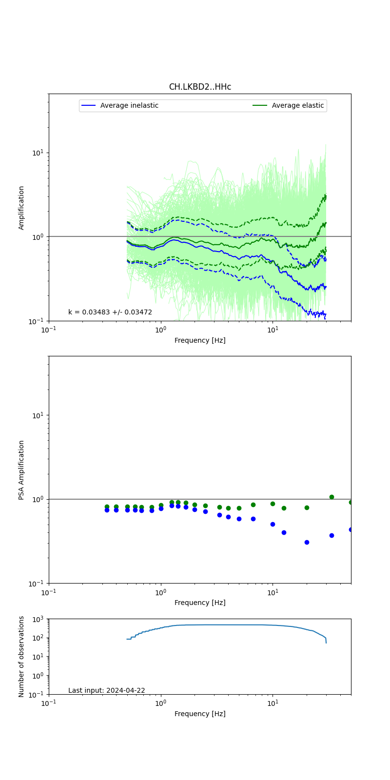 |
| CH.LKBD2..HG |  |
Obtained from spectral modeling of small earthquakes with constant update.
- Top: Fourier amplification with elastic (dashed line) and anelastic (solid line) amplification functions;
- Centre: 5% damped response spectra amplification (anelastic);
- Bottom: Number of recordings used.
See Edwards et al. (2013), Determination of Site Amplification from Regional Seismicity: Application to the Swiss National Seismic Networks. Seismological Research Letters, 84(4), 611–621.
| measurements nearby | list... |
|---|