Station Overview
| Overview Location | not available |
|---|---|
| Picture Gallery | details... |
| Geological Unit | Siliceous limestone with hauterivian age (Cretaceous - nappe of Morcles) |
|---|---|
| Site Morphology Class |
T2 T1: flat; T2: slope; T3: ridge and T4: steep ridge; following Pessina and Fiorini (2014) A GIS procedure for fast topographic characterization of seismic recording stations, Soil Dynamics and Earthquake Engineering, 63, p248-258 |
| Site Morphology Description | Rock cliff |
| Ground type EC8 | |
| Ground type SIA | |
| Basin Information | not in a sedimentary basin with possible 2D/3D effects |
| Reference |
Current Instrumentation
| Location code | (none) |
|---|---|
| On date | 22-08-2019 15:00:00 |
| Off date | - |
| Sensor model | EpiSensor ES-T |
| Sensor manufacturer | Kinemetrics |
| Digitizer model | Centaur |
| Digitizer manufacturer | Nanometrics |
| Channels | HGE , HGN , HGZ |
| Stream Noise (last week) | HGE , HGN , HGZ |
| Location code | (none) |
|---|---|
| On date | 22-08-2019 15:00:00 |
| Off date | - |
| Sensor model | Trillium 240s_g2 |
| Sensor manufacturer | Nanometrics |
| Digitizer model | Centaur |
| Digitizer manufacturer | Nanometrics |
| Channels | BHE , BHN , BHZ , HHE , HHN , HHZ |
| Stream Noise (last week) | BHE , BHN , BHZ , HHE , HHN , HHZ |
| Location code | (none) |
|---|---|
| On date | 04-07-2019 09:28:00 |
| Off date | 2019-08-22 15:00:00 |
| Waveform Access | open |
| Sensor model | LE-3D-5s |
| Sensor manufacturer | Lennartz |
| Digitizer model | HRD24 |
| Digitizer manufacturer | Nanometrics |
| Channels | EHE , EHN , EHZ |
| Location code | (none) |
|---|---|
| On date | 03-06-2009 00:00:00 |
| Off date | 2019-06-26 11:50:00 |
| Waveform Access | open |
| Sensor model | LE-3D-5s |
| Sensor manufacturer | Lennartz |
| Digitizer model | HRD24 |
| Digitizer manufacturer | Nanometrics |
| Channels | EHE , EHN , EHZ |
| Location code | (none) |
|---|---|
| On date | 10-10-2002 14:00:00 |
| Off date | 2009-06-03 00:00:00 |
| Waveform Access | open |
| Sensor model | LE-3D-5s |
| Sensor manufacturer | Lennartz |
| Digitizer model | HRD24 |
| Digitizer manufacturer | Nanometrics |
| Channels | EHE , EHN , EHZ |
Site Characterization
|
channel group |
Empirical Amplification |
|---|---|
| CH.GRYON..HH | 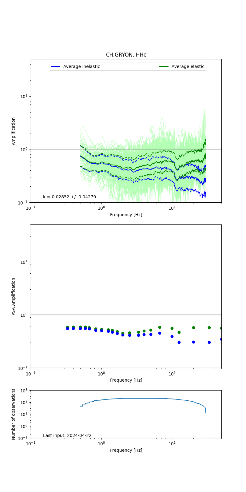 |
| CH.GRYON..HG | 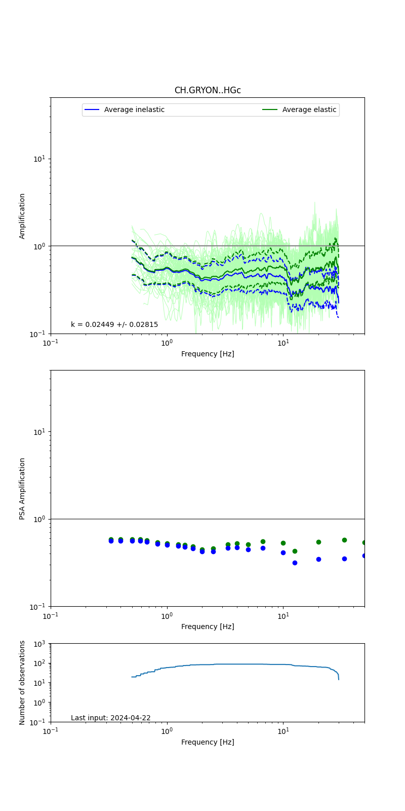 |
| CH.GRYON..EH | 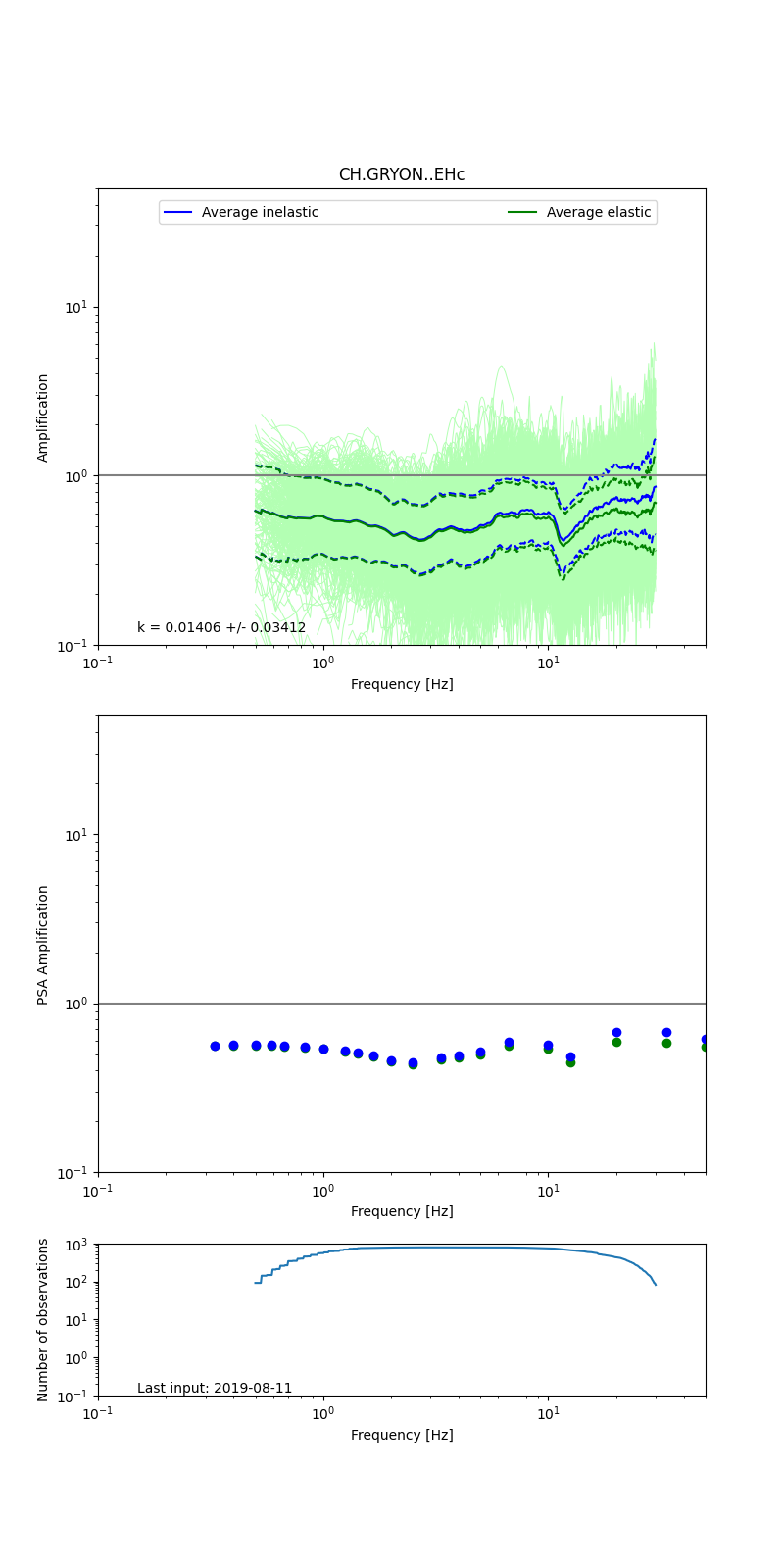 |
Obtained from spectral modeling of small earthquakes with constant update.
- Top: Fourier amplification with elastic (dashed line) and anelastic (solid line) amplification functions;
- Centre: 5% damped response spectra amplification (anelastic);
- Bottom: Number of recordings used.
See Edwards et al. (2013), Determination of Site Amplification from Regional Seismicity: Application to the Swiss National Seismic Networks. Seismological Research Letters, 84(4), 611–621.
| measurements nearby | list... |
|---|