Station Overview

Overview Location not available
Picture Gallery details...
Network CH
Station Code EWZT2
Station Description Wettswil, ZH
Latitude (WGS84) 47.33732
Longitude (WGS84) 8.49319
Station altitude (CH1903) 690.0
running from 2009-08-29
...until now
Waveform Access open
Sensor Types Velocimeter
Geological Unit Moraine of Riss age (Pleistocene)
Site Morphology Class
Site Morphology Description Hillside
Ground type EC8
Ground type SIA
Basin Information not in a sedimentary basin with possible 2D/3D effects
Reference
Resonance Frequency (Hz) 1.81
Uncertainty Factor -
Vs 30 (m/s) -
Location Map


Federal Office of Topograpy: National Map 1:25‘000
Topography Map


Federal Office of Topograpy: DHM25: Digital Height Model 1:25000
Geology Map

Federal Office of Topograpy: Geological map of Switzerland 1:500‘000

Sensor locations

Location Code (none)
Opening Date 29-08-2009
End Date -
Housing Class Underground shelter
Housing Description Sensor in underground shelter, concrete structure beside water reservoir, 8m directly below free surface, 10m from nearest entrance. Sensor placed directly on concrete floor on rock.
sensor depth below station 8.0 m
Distance to Building (m) -

Current Instrumentation

Location code (none)
On date 29-08-2023 10:04:11
Off date -
Sensor model LE-3D-1s
Sensor manufacturer Lennartz
Digitizer model Taurus
Digitizer manufacturer Nanometrics
Channels EHE , EHN , EHZ
Stream Noise (last week) EHE , EHN , EHZ

Site Characterization

channel group
Empirical Amplification
CH.EWZT2..EH not available

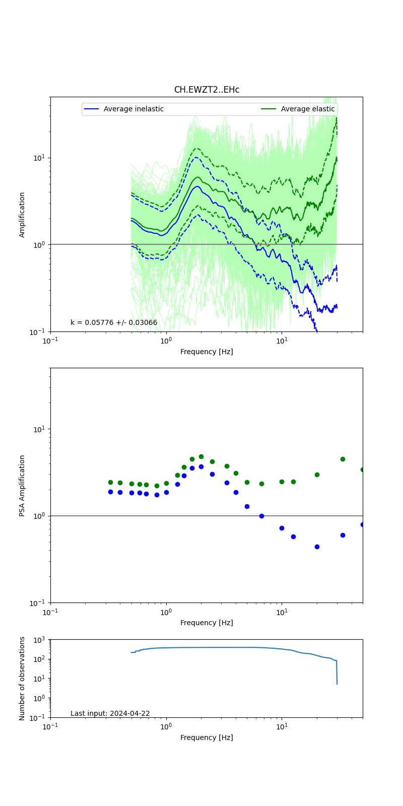
Obtained from spectral modeling of small earthquakes with constant update.

  • Top: Fourier amplification with elastic (dashed line) and anelastic (solid line) amplification functions;
  • Centre: 5% damped response spectra amplification (anelastic);
  • Bottom: Number of recordings used.

See Edwards et al. (2013), Determination of Site Amplification from Regional Seismicity: Application to the Swiss National Seismic Networks. Seismological Research Letters, 84(4), 611–621.

H/V pick image:
Authoritative Site Characterization Analysis -
measurements nearby list...