Sensor locations
| Location Code | BT |
|---|---|
| Opening Date | 22-12-2022 |
| End Date | - |
| Housing Class | Borehole |
| Housing Description | casing: plastic casing; casing length: 102.4 m; diameter: [7.5 cm]; locking mechanism: Lennartz holelock; water inside of the borehole. |
| sensor depth below station | 100.0 m |
| Distance to Building (m) | - |
| Location Code | SF |
|---|---|
| Opening Date | 22-12-2022 |
| End Date | - |
| Housing Class | Free field |
| Housing Description | EPI sensor installed in a seprate vault. Vault is 0.5m south and 2.6m east of the final coordinates. sensor mounted on a conret plate. |
| sensor depth below station | 1.0 m |
| Distance to Building (m) | - |
Current Instrumentation
| Location code | BT |
|---|---|
| On date | 22-12-2022 09:00:00 |
| Off date | - |
| Sensor model | LE-3D-BH |
| Sensor manufacturer | Lennartz |
| Digitizer model | Centaur |
| Digitizer manufacturer | Nanometrics |
| Channels | EH1 , EH2 , EHZ |
| Stream Noise (last week) | EH1 , EH2 , EHZ |
| Location code | SF |
|---|---|
| On date | 22-12-2022 09:00:00 |
| Off date | - |
| Sensor model | EpiSensor ES-T |
| Sensor manufacturer | Kinemetrics |
| Digitizer model | Centaur |
| Digitizer manufacturer | Nanometrics |
| Channels | HGE , HGN , HGZ |
| Stream Noise (last week) | HGE , HGN , HGZ |
Site Characterization
|
channel group |
Empirical Amplification |
|---|---|
| CH.CHALL.SF.HG |  |
| CH.CHALL.BT.EH | 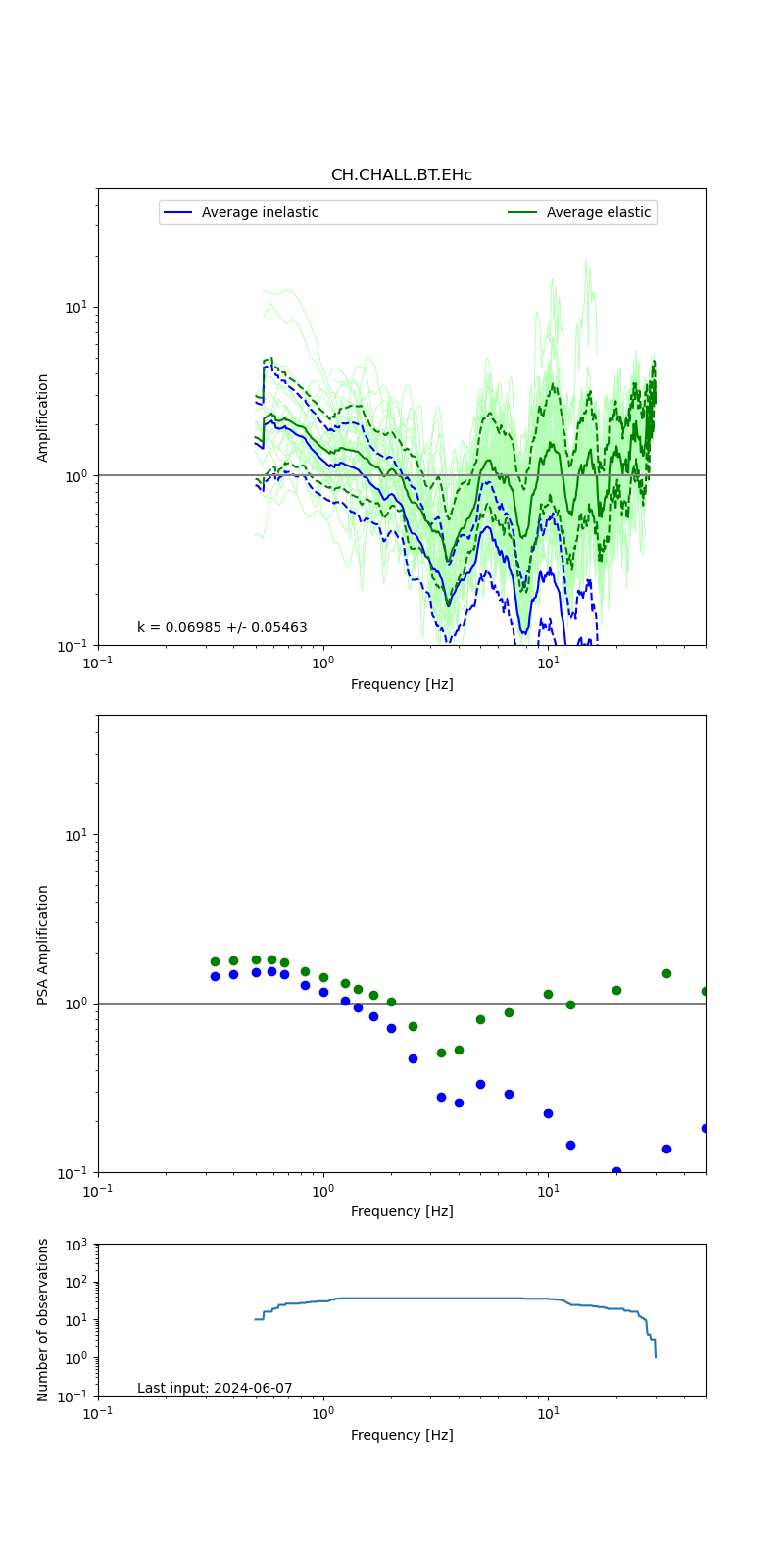 |
Obtained from spectral modeling of small earthquakes with constant update.
- Top: Fourier amplification with elastic (dashed line) and anelastic (solid line) amplification functions;
- Centre: 5% damped response spectra amplification (anelastic);
- Bottom: Number of recordings used.
See Edwards et al. (2013), Determination of Site Amplification from Regional Seismicity: Application to the Swiss National Seismic Networks. Seismological Research Letters, 84(4), 611–621.
| measurements nearby | list... |
|---|