Station Overview
| Overview Location |
 |
|---|---|
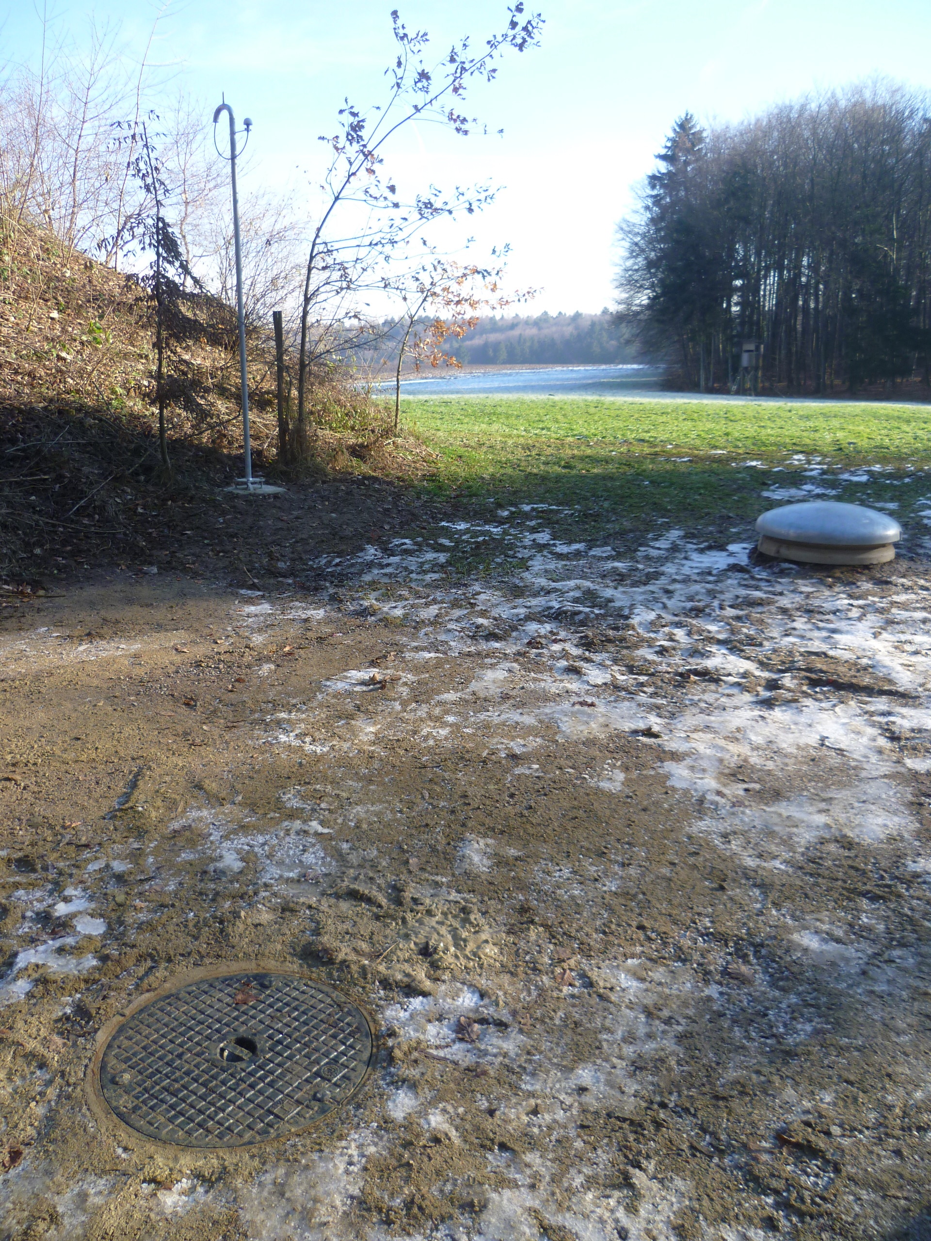
| Picture Gallery | details... |
| Geological Unit | Fluvial glacial sediments on sandstones and marls of Miocene age (Upper Freshwater Molasse - Tertiary) |
|---|---|
| Site Morphology Class |
T1 T1: flat; T2: slope; T3: ridge and T4: steep ridge; following Pessina and Fiorini (2014) A GIS procedure for fast topographic characterization of seismic recording stations, Soil Dynamics and Earthquake Engineering, 63, p248-258 |
| Site Morphology Description | Top of a hill/plateau |
| Ground type EC8 | B |
| Ground type SIA | E |
| Basin Information | not in a sedimentary basin with possible 2D/3D effects |
| Reference | Poggi Valerio, Fäh D., "Böbikon, Switzerland (BOBI) Report on site characterization", Swiss Seismological Service, ETH Zürich, 2014 |
Sensor locations
| Location Code | BT |
|---|---|
| Opening Date | 20-12-2013 |
| End Date | - |
| Housing Class | Borehole |
| Housing Description | Casing: steel; casing length 158m; diameter 8.4cm (inner), 10.16 cm (outer); locking mechanism: Lennartz hole lock; dry; <2deg off vertical; emplacement depth 154m; Sensor cable with SED custom built strain relief at borehole head. |
| sensor depth below station | 154.0 m |
| Distance to Building (m) | - |
| Location Code | SF |
|---|---|
| Opening Date | 20-12-2013 |
| End Date | - |
| Housing Class | Free field |
| Housing Description | SED large pot in soil |
| sensor depth below station | 1.0 m |
| Distance to Building (m) | - |
Current Instrumentation
| Location code | BT |
|---|---|
| On date | 05-07-2024 09:17:00 |
| Off date | - |
| Sensor model | LE-3D-BH |
| Sensor manufacturer | Lennartz |
| Digitizer model | Q330HRS |
| Digitizer manufacturer | Quanterra |
| Channels | EH2 , EH3 , EHZ |
| Stream Noise (last week) | EH2 , EH3 , EHZ |
| Location code | SF |
|---|---|
| On date | 18-12-2024 13:30:00 |
| Off date | - |
| Sensor model | EpiSensor ES-T |
| Sensor manufacturer | Kinemetrics |
| Digitizer model | Q330HRS |
| Digitizer manufacturer | Quanterra |
| Channels | HGE , HGN , HGZ |
| Stream Noise (last week) | HGE , HGN , HGZ |
| Location code | BT |
|---|---|
| On date | 21-11-2016 15:30:00 |
| Off date | 2024-07-05 09:17:00 |
| Waveform Access | open |
| Sensor model | LE-3D-BH |
| Sensor manufacturer | Lennartz |
| Digitizer model | Q330Splus |
| Digitizer manufacturer | Quanterra |
| Channels | EH2 , EH3 , EHZ |
| Location code | BT |
|---|---|
| On date | 20-12-2013 14:00:00 |
| Off date | 2016-11-21 15:30:00 |
| Waveform Access | open |
| Sensor model | LE-3D-BH |
| Sensor manufacturer | Lennartz |
| Digitizer model | Q330Splus |
| Digitizer manufacturer | Quanterra |
| Channels | EH2 , EH3 , EHZ |
| Location code | SF |
|---|---|
| On date | 05-07-2024 09:17:00 |
| Off date | 2024-12-18 13:30:00 |
| Waveform Access | open |
| Sensor model | EpiSensor ES-T |
| Sensor manufacturer | Kinemetrics |
| Digitizer model | Q330HRS |
| Digitizer manufacturer | Quanterra |
| Channels | HGE , HGN , HGZ |
| Location code | SF |
|---|---|
| On date | 21-11-2016 15:30:00 |
| Off date | 2024-07-05 09:17:00 |
| Waveform Access | open |
| Sensor model | EpiSensor ES-T |
| Sensor manufacturer | Kinemetrics |
| Digitizer model | Q330Splus |
| Digitizer manufacturer | Quanterra |
| Channels | HGE , HGN , HGZ |
| Location code | SF |
|---|---|
| On date | 20-12-2013 14:00:00 |
| Off date | 2016-11-21 15:30:00 |
| Waveform Access | open |
| Sensor model | EpiSensor ES-T |
| Sensor manufacturer | Kinemetrics |
| Digitizer model | Q330Splus |
| Digitizer manufacturer | Quanterra |
| Channels | HGE , HGN , HGZ |
Site Characterization
|
channel group |
Empirical Amplification |
|---|---|
| CH.BOBI.SF.HG | 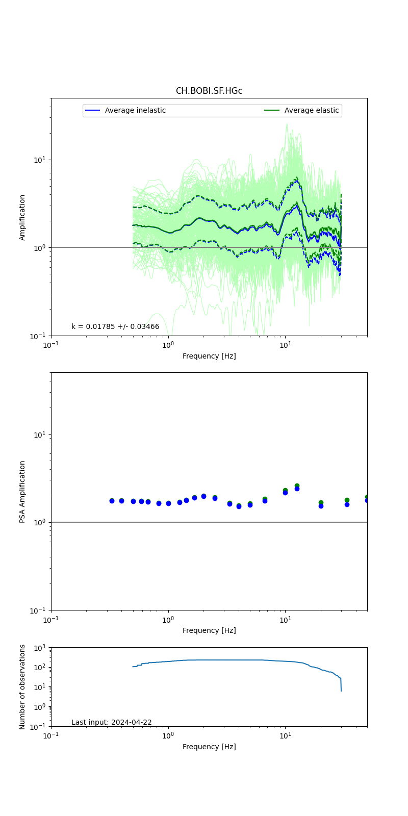 |
| CH.BOBI.BT.EH | 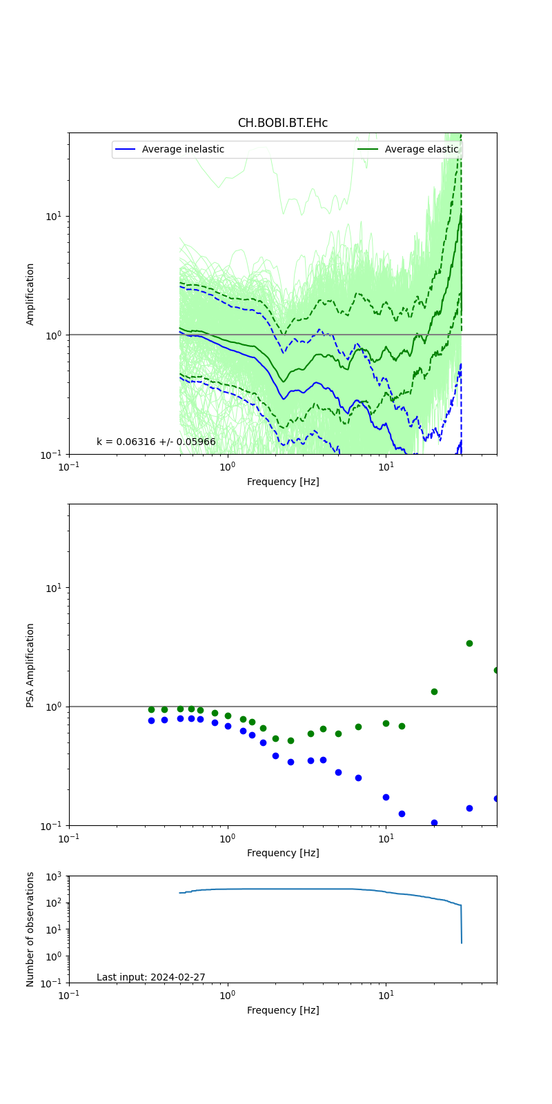 |
Obtained from spectral modeling of small earthquakes with constant update.
- Top: Fourier amplification with elastic (dashed line) and anelastic (solid line) amplification functions;
- Centre: 5% damped response spectra amplification (anelastic);
- Bottom: Number of recordings used.
See Edwards et al. (2013), Determination of Site Amplification from Regional Seismicity: Application to the Swiss National Seismic Networks. Seismological Research Letters, 84(4), 611–621.
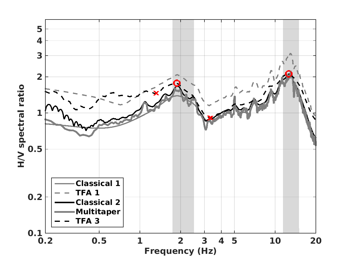
| H/V pick image: |
 |
|---|---|
| Authoritative Site Characterization Analysis | details... |
| measurements nearby | list... |
|---|